Thread on Evolution of Sino-India Border
I expect followers not to tag official govt handles and create unnecessary hype.
Lets first go back to 2 main great Chinese extents-
Ming Dynasty with independent Tibet 1368-1644


The defeat of the 1791 Nepalese invasion increased the Qing's control over Tibet.
This is 1820 qing claim possibly at the behest of Ambans.

This is the boundary which india officially claim
This is the border Republic of India has inherited and is its official claim based on Dogra and 1914 Simla maps.

Map published by china in 1933 putting aksai chin inside India.

Let us come to post independence.
The Chinese built the road and India was not knowing since 1957, when india protested the Chinese claimed that they have already annexed half of aksai chin
This claim line includes 70% of Aksai chin but includes arunachal as a part of India.
In 24 oct 1962, China invaded further and occupied Aksai Chin and also occupying galwan valley and Depsang Plains.

As far as Congress is concerned the Chinese thus invaded India between 2001-2013, 14 times occupying 900-2000 sq km every time
1. Galwan clash- Most violent claiming casulities, Chinese incursion thwarted


This area saw Chinese occupation 4 times under UPA regime, I will discuss 2020 only.
I might get bashed by BJP and bhaktas badly but what I feel Modi lied when he said not an inch of our land has been occupied
More from India
Dumb£dk@r wasn't like Pe£riyar?
He was an Anti-Hindu m0r0n just like Periy@r.
Yes it's true that he criticised K2@s but that doesn't make him any useful for Hindus.
His writings will remind you a lot of JNU Urban Naxals like Kanhaiya.
"Ancient Hindus had no sexual morals, brother cohabited with sister, son with mother, father with daughter... Men freely shared women & none had exclusive right over her... Prostitution flourished in the worst form...bestiality prevailed, done even by Rishis."
Riddles in Hinduism

This is what Shri Ram said in Kishkindha-Kanda of Valmiki Ramayana regarding such immoral relationships.
But how could Neela Katt@ppa not realize this?
Because he severely lacking analytical capabilities of Hindu texts.

"Hindu Gods were miserable cowards who had to hide behind their wives to save themselves from Asuras. How could these cowards give power to Shakti? Did the Brahmins invent the practice of worshipping of Goddesses to put a new commodity in the market?"
Riddles in Hinduism.

He was an Anti-Hindu m0r0n just like Periy@r.
A wonderful piece from the Quora space "Tamil Right-Wingers"https://t.co/qokR0GQw4A
— Soumili Das (\u0938\u094c\u092e\u093f\u0932\u0940 \u0926\u093e\u0938 ) (\u09b8\u09cc\u09ae\u09bf\u09b2\u09c0 \u09a6\u09be\u09b8 ) (@Soumili_Squeaks) February 2, 2021
Yes it's true that he criticised K2@s but that doesn't make him any useful for Hindus.
His writings will remind you a lot of JNU Urban Naxals like Kanhaiya.
"Ancient Hindus had no sexual morals, brother cohabited with sister, son with mother, father with daughter... Men freely shared women & none had exclusive right over her... Prostitution flourished in the worst form...bestiality prevailed, done even by Rishis."
Riddles in Hinduism

This is what Shri Ram said in Kishkindha-Kanda of Valmiki Ramayana regarding such immoral relationships.
But how could Neela Katt@ppa not realize this?
Because he severely lacking analytical capabilities of Hindu texts.

"Hindu Gods were miserable cowards who had to hide behind their wives to save themselves from Asuras. How could these cowards give power to Shakti? Did the Brahmins invent the practice of worshipping of Goddesses to put a new commodity in the market?"
Riddles in Hinduism.

You May Also Like
THREAD PART 1.
On Sunday 21st June, 14 year old Noah Donohoe left his home to meet his friends at Cave Hill Belfast to study for school. #RememberMyNoah💙

He was on his black Apollo mountain bike, fully dressed, wearing a helmet and carrying a backpack containing his laptop and 2 books with his name on them. He also had his mobile phone with him.
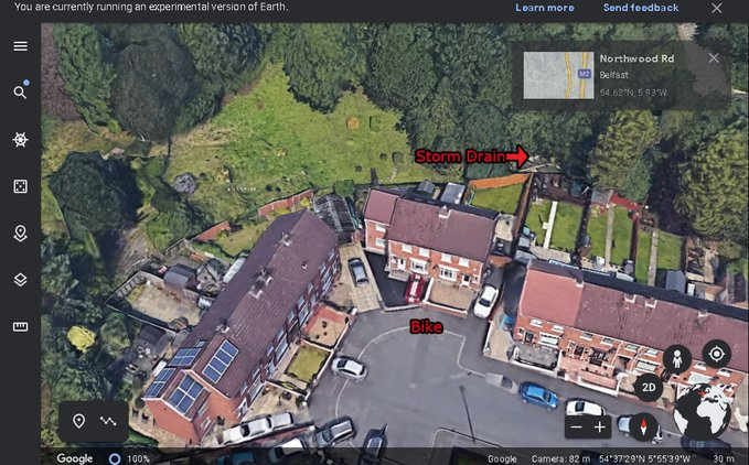
On the 27th of June. Noah's naked body was sadly discovered 950m inside a storm drain, between access points. This storm drain was accessible through an area completely unfamiliar to him, behind houses at Northwood Road. https://t.co/bpz3Rmc0wq

"Noah's body was found by specially trained police officers between two drain access points within a section of the tunnel running under the Translink access road," said Mr McCrisken."
Noah's bike was also found near a house, behind a car, in the same area. It had been there for more than 24 hours before a member of public who lived in the street said she read reports of a missing child and checked the bike and phoned the police.
On Sunday 21st June, 14 year old Noah Donohoe left his home to meet his friends at Cave Hill Belfast to study for school. #RememberMyNoah💙

He was on his black Apollo mountain bike, fully dressed, wearing a helmet and carrying a backpack containing his laptop and 2 books with his name on them. He also had his mobile phone with him.
On the 27th of June. Noah's naked body was sadly discovered 950m inside a storm drain, between access points. This storm drain was accessible through an area completely unfamiliar to him, behind houses at Northwood Road. https://t.co/bpz3Rmc0wq

"Noah's body was found by specially trained police officers between two drain access points within a section of the tunnel running under the Translink access road," said Mr McCrisken."
Noah's bike was also found near a house, behind a car, in the same area. It had been there for more than 24 hours before a member of public who lived in the street said she read reports of a missing child and checked the bike and phoned the police.
I'm going to do two history threads on Ethiopia, one on its ancient history, one on its modern story (1800 to today). 🇪🇹
I'll begin with the ancient history ... and it goes way back. Because modern humans - and before that, the ancestors of humans - almost certainly originated in Ethiopia. 🇪🇹 (sub-thread):
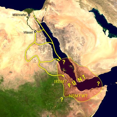
The first likely historical reference to Ethiopia is ancient Egyptian records of trade expeditions to the "Land of Punt" in search of gold, ebony, ivory, incense, and wild animals, starting in c 2500 BC 🇪🇹

Ethiopians themselves believe that the Queen of Sheba, who visited Israel's King Solomon in the Bible (c 950 BC), came from Ethiopia (not Yemen, as others believe). Here she is meeting Solomon in a stain-glassed window in Addis Ababa's Holy Trinity Church. 🇪🇹

References to the Queen of Sheba are everywhere in Ethiopia. The national airline's frequent flier miles are even called "ShebaMiles". 🇪🇹

I'll begin with the ancient history ... and it goes way back. Because modern humans - and before that, the ancestors of humans - almost certainly originated in Ethiopia. 🇪🇹 (sub-thread):
The famous \u201cLucy\u201d, an early ancestor of modern humans (Australopithecus) that lived 3.2 million years ago, and was discovered in 1974 in Ethiopia, displayed in the national museum in Addis Ababa \U0001f1ea\U0001f1f9 pic.twitter.com/N3oWqk1SW2
— Patrick Chovanec (@prchovanec) November 9, 2018
The first likely historical reference to Ethiopia is ancient Egyptian records of trade expeditions to the "Land of Punt" in search of gold, ebony, ivory, incense, and wild animals, starting in c 2500 BC 🇪🇹

Ethiopians themselves believe that the Queen of Sheba, who visited Israel's King Solomon in the Bible (c 950 BC), came from Ethiopia (not Yemen, as others believe). Here she is meeting Solomon in a stain-glassed window in Addis Ababa's Holy Trinity Church. 🇪🇹

References to the Queen of Sheba are everywhere in Ethiopia. The national airline's frequent flier miles are even called "ShebaMiles". 🇪🇹


