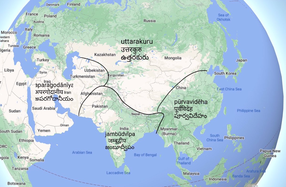
In this thread, I will discuss the division of earth into continents, and how the term “Jambūdwīpa” जम्बूद्वीप, perhaps attested the most number of times in world literature as a continent, lost out to the bastard time “South Asia”.
India must reclaim the term “Jambūdwīpa”.

More detail can be seen here: https://t.co/fN3vG5PL1C
The Hindu accounts in various Purānas are similar: https://t.co/6CX9ykE2eL
This is similar to how the Greeks named the continents: by extending the names of Greek places that lie in those directions.
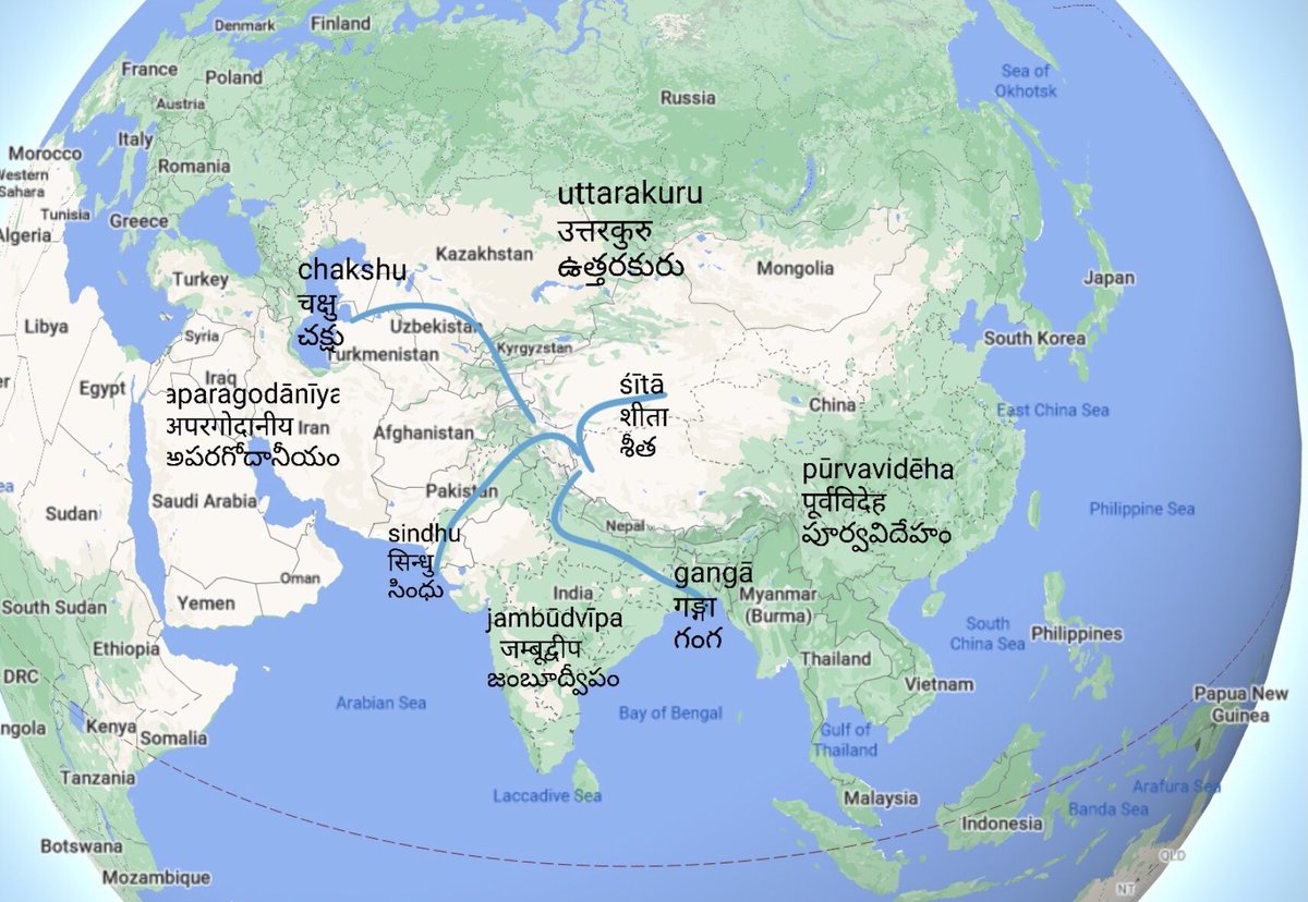
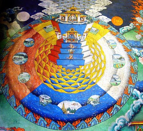
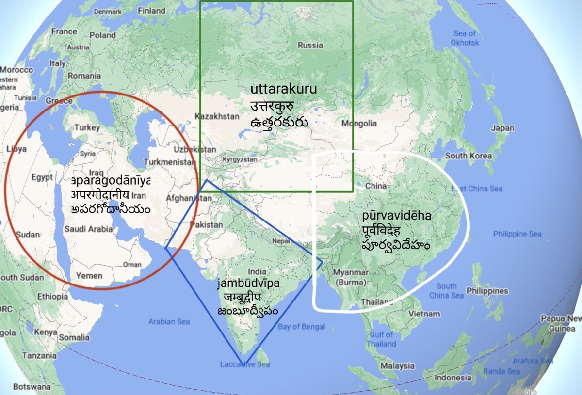
One fascinating description of the geography of India is its mythical image as the \u201cJamb\u016b Dw\u012bpa\u201d, which has much philosophical imagery. As a devout Buddhist, Hiuen Tsang starts off with the description in Mah\u0101 Praj\xf1apar\u0101mita S\u016btra.https://t.co/BZR65KdxCK pic.twitter.com/lNPj5jclFp
— vakibs (@vakibs) August 1, 2020
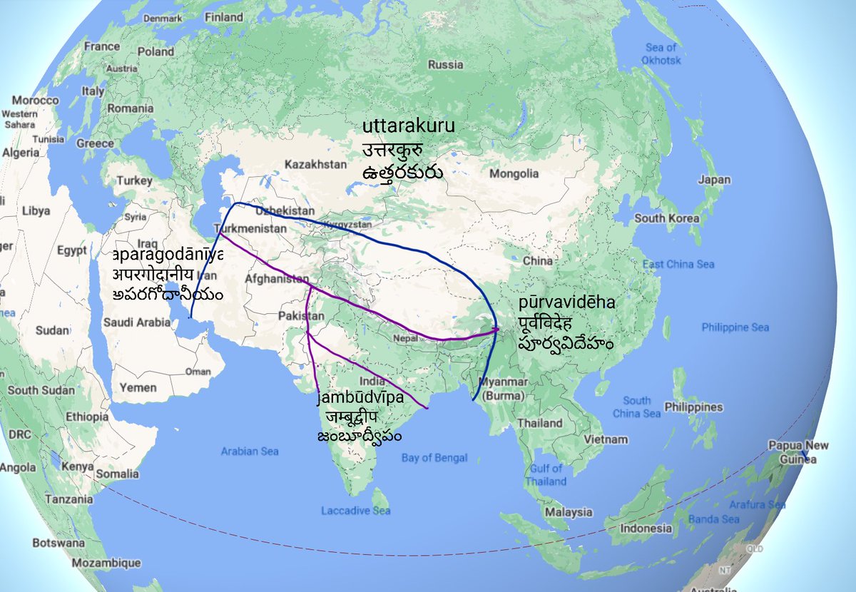
Hiuen Tsang recounts the principal sources of political strength in the 4 zones of the geography.
— vakibs (@vakibs) August 1, 2020
Horses, in the north
Trade, in the west
Elephants, in the south
Men, in the east
Indian kings were known as \u201ca\u015bwapati, narapati, gajapati\u201d etc based on mastery of these resources. pic.twitter.com/6BKSfXB95a

More from India

Some readers have been asking what #India2030 is all about.
Here’s a chapter-by-chapter thread on the 20 forecasts by 20 thought leaders on 20 themes that will define India in the 2020s.
1/n
Chapter 20 of #India2030 by @davidfrawleyved talks about how the Civilizational Resurgence of India will reconnect its ancient past to ride into a dharmic future
2/n
Chapter 19 of #India2030 by @devdip tells us what the new idea of Nationalism in the 2020s will be — an integral union of the nation with the self
3/n
Chapter 18 of #India2030 by @sandipanthedeb examines how ideologies and technologies will intrude into and redefine Friendships
4/n
Chapter 17 of #India2030 by @authoramish studies the Soft Power of India and says its global influence will be through the confluence of materialism and spiritualism
5/n
Here’s a chapter-by-chapter thread on the 20 forecasts by 20 thought leaders on 20 themes that will define India in the 2020s.
1/n
Delighted to announce the forthcoming release of my fifth book \u2014 #India2030: The Rise of a Rajasic Nation.
— Gautam Chikermane (@gchikermane) January 13, 2021
It hits the bookstores on 25 January.
Gratitude to my contributors and @PenguinIndia for partnering this adventure. pic.twitter.com/I0SdQk19JG
Chapter 20 of #India2030 by @davidfrawleyved talks about how the Civilizational Resurgence of India will reconnect its ancient past to ride into a dharmic future
2/n
Chapter 19 of #India2030 by @devdip tells us what the new idea of Nationalism in the 2020s will be — an integral union of the nation with the self
3/n
Chapter 18 of #India2030 by @sandipanthedeb examines how ideologies and technologies will intrude into and redefine Friendships
4/n
Chapter 17 of #India2030 by @authoramish studies the Soft Power of India and says its global influence will be through the confluence of materialism and spiritualism
5/n


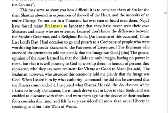
In his letters describing the India Mission, Carey has given us an insight into how the society functioned then, of how the minds of the people worked and what methods the missionaries used to approach and brainwash the common people.
It is entirely possible that,Carey in his arrogance of being the white man and hence more civilized,his inability to under the Hindu scriptures and his natural disdain for the learned community coupled with his inherent hatred for the idolaters may have exaggerated the incidents.
In fact, considering the venom with which he has spoken about Hinduism and it's practices, it's likely that he has exaggerated these incidents. But it cannot be denied that these incidents did happen even if they may not have been on scale at which Carey has described.
One of his journal entry mentions a debate which happened in a temple in front of around 200 people. Carey describes having debated with two learned men and goes on to say when both learned men failed to answer his questions, he went on to preach the gospel to the assembled crowd
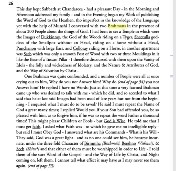
In a letter dated 30th June,1795 he goes on to gleefully narate how Hindus were unaware of their own scriptures and how an supposed expert named a grammar book when he was questioned as which scripture said that the Murti is God.
William Carey landed on the Indian soil in the year 1793. He spent the remaining years of his life in India. He was a British missionary, a translator and a social reformer who is best known for having the practice of Sati abolished in India. https://t.co/kRiPwgjwcP pic.twitter.com/JqO3A7cCsX
— Tanvangi (@Tanvangi17) December 18, 2020
It is entirely possible that,Carey in his arrogance of being the white man and hence more civilized,his inability to under the Hindu scriptures and his natural disdain for the learned community coupled with his inherent hatred for the idolaters may have exaggerated the incidents.
In fact, considering the venom with which he has spoken about Hinduism and it's practices, it's likely that he has exaggerated these incidents. But it cannot be denied that these incidents did happen even if they may not have been on scale at which Carey has described.
One of his journal entry mentions a debate which happened in a temple in front of around 200 people. Carey describes having debated with two learned men and goes on to say when both learned men failed to answer his questions, he went on to preach the gospel to the assembled crowd
In a letter dated 30th June,1795 he goes on to gleefully narate how Hindus were unaware of their own scriptures and how an supposed expert named a grammar book when he was questioned as which scripture said that the Murti is God.


Hindutva does not belong to Modi nor his party, it belongs to the people as a unifying, decolonial ideology similar to pan-Africanism or Yugoslavism.
His own brand of "positive secularism" is even milder - deepening special rights and welfare schemes for religious minorities.
After the disbanding of the Hindu Mahasabha and Jana Sangh, Hindutva as a political ideology does not even exist, except as a bogeyman in the minds of the Anglophone elite.
Even the BJP gave up Hindutva for civic nationalism, Gandhian socialism, and positive secularism in 1980s.
Under Modi, there has been compete policy continuity on minority rights and welfare from the Congress era, with little to no "Hindutva agenda" coming to see the light of day.
The most radical policy they can dream of is religion-neutral laws and equal rights for equal citizens.
Hindutva was essential in forming a national consciousness, but was abandoned with time. The modern BJP refuses to self-identify as a Hindutva movement, adopting moderates like Sardar Patel, Deendayal Upadhyay, and JP Narayan as their icons, rather than Savarkar or the Mahasabha.
When they say Hindu Rashtra, all they mean is an "Indic polity".
When British India was partitioned into a Muslim homeland and a Dharmic homeland, one state became a 'Ghazi' garrison state, and one the successor state to the Indic
His own brand of "positive secularism" is even milder - deepening special rights and welfare schemes for religious minorities.
I'm not entirely comfortable with Modi's "Hindutva".
— Onye Nkuzi (@cchukudebelu) February 2, 2021
I know many of my Indian followers will come at me, angrily - but let me just say this out.
I'm not sure it is a great model for democracy in a diverse, multi-cultural developing nation.
After the disbanding of the Hindu Mahasabha and Jana Sangh, Hindutva as a political ideology does not even exist, except as a bogeyman in the minds of the Anglophone elite.
Even the BJP gave up Hindutva for civic nationalism, Gandhian socialism, and positive secularism in 1980s.
Under Modi, there has been compete policy continuity on minority rights and welfare from the Congress era, with little to no "Hindutva agenda" coming to see the light of day.
The most radical policy they can dream of is religion-neutral laws and equal rights for equal citizens.
Hindutva was essential in forming a national consciousness, but was abandoned with time. The modern BJP refuses to self-identify as a Hindutva movement, adopting moderates like Sardar Patel, Deendayal Upadhyay, and JP Narayan as their icons, rather than Savarkar or the Mahasabha.
When they say Hindu Rashtra, all they mean is an "Indic polity".
When British India was partitioned into a Muslim homeland and a Dharmic homeland, one state became a 'Ghazi' garrison state, and one the successor state to the Indic
You May Also Like


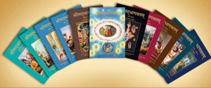
IMPORTANCE, ADVANTAGES AND CHARACTERISTICS OF BHAGWAT PURAN
It was Ved Vyas who edited the eighteen thousand shlokas of Bhagwat. This book destroys all your sins. It has twelve parts which are like kalpvraksh.
In the first skandh, the importance of Vedvyas
and characters of Pandavas are described by the dialogues between Suutji and Shaunakji. Then there is the story of Parikshit.
Next there is a Brahm Narad dialogue describing the avtaar of Bhagwan. Then the characteristics of Puraan are mentioned.
It also discusses the evolution of universe.( https://t.co/2aK1AZSC79 )
Next is the portrayal of Vidur and his dialogue with Maitreyji. Then there is a mention of Creation of universe by Brahma and the preachings of Sankhya by Kapil Muni.
In the next section we find the portrayal of Sati, Dhruv, Pruthu, and the story of ancient King, Bahirshi.
In the next section we find the character of King Priyavrat and his sons, different types of loks in this universe, and description of Narak. ( https://t.co/gmDTkLktKS )
In the sixth part we find the portrayal of Ajaamil ( https://t.co/LdVSSNspa2 ), Daksh and the birth of Marudgans( https://t.co/tecNidVckj )
In the seventh section we find the story of Prahlad and the description of Varnashram dharma. This section is based on karma vaasna.
It was Ved Vyas who edited the eighteen thousand shlokas of Bhagwat. This book destroys all your sins. It has twelve parts which are like kalpvraksh.
In the first skandh, the importance of Vedvyas
and characters of Pandavas are described by the dialogues between Suutji and Shaunakji. Then there is the story of Parikshit.
Next there is a Brahm Narad dialogue describing the avtaar of Bhagwan. Then the characteristics of Puraan are mentioned.
It also discusses the evolution of universe.( https://t.co/2aK1AZSC79 )
Next is the portrayal of Vidur and his dialogue with Maitreyji. Then there is a mention of Creation of universe by Brahma and the preachings of Sankhya by Kapil Muni.
HOW LIFE EVOLVED IN THIS UNIVERSE AS PER OUR SCRIPTURES.
— Anshul Pandey (@Anshulspiritual) August 29, 2020
Well maximum of Living being are the Vansaj of Rishi Kashyap. I have tried to give stories from different-different Puran. So lets start.... pic.twitter.com/MrrTS4xORk
In the next section we find the portrayal of Sati, Dhruv, Pruthu, and the story of ancient King, Bahirshi.
In the next section we find the character of King Priyavrat and his sons, different types of loks in this universe, and description of Narak. ( https://t.co/gmDTkLktKS )
Thread on NARK(HELL) / \u0928\u0930\u094d\u0915
— Anshul Pandey (@Anshulspiritual) August 11, 2020
Well today i will take you to a journey where nobody wants to go i.e Nark. Hence beware of doing Adharma/Evil things. There are various mentions in Puranas about Nark, But my Thread is only as per Bhagwat puran(SS attached in below Thread)
1/8 pic.twitter.com/raHYWtB53Q
In the sixth part we find the portrayal of Ajaamil ( https://t.co/LdVSSNspa2 ), Daksh and the birth of Marudgans( https://t.co/tecNidVckj )
In the seventh section we find the story of Prahlad and the description of Varnashram dharma. This section is based on karma vaasna.
#THREAD
— Anshul Pandey (@Anshulspiritual) August 12, 2020
WHY PARENTS CHOOSE RELIGIOUS OR PARAMATMA'S NAMES FOR THEIR CHILDREN AND WHICH ARE THE EASIEST WAY TO WASH AWAY YOUR SINS.
Yesterday I had described the types of Naraka's and the Sin or Adharma for a person to be there.
1/8 pic.twitter.com/XjPB2hfnUC