
With that said, for my frog and frog-adjacent bros and sisters:
OK I am going to be tackling this as surveillance/open source intel gathering exercise, because that is my background. I blew away 3 years of my life doing site acquisition/reconnaissance for a certain industry that shall remain unnamed and believe there is significant carryover.
If I did thred on finding/acquiring decent raw land would that be something pepo are interested in
— Ovcharka (@ouroboros_outis) January 18, 2021
I think I know a bunch of weird tips/tricks for selection at this point that it might help u guys, lemme know
With that said, for my frog and frog-adjacent bros and sisters:
Zillow is obvious one, but there are many good sites like Billy Land, Classic Country Land, Landwatch, etc. and many of these specialize in owner financing (more on that later.) Do NOT treat these as authoritative sources - trust plat maps and parcel viewers.
Okay, everyone knows how to google "raw land in x state" but there are other resources out there, including state Departments of Natural Resources, foreclosure auctions, etc. Finding the land you like is the easy part. Let's do a case study.
Note: visible power, power/fiber pedestal, utility corridor, nearby commercial enterprise(s), and utility pole shadows visible.
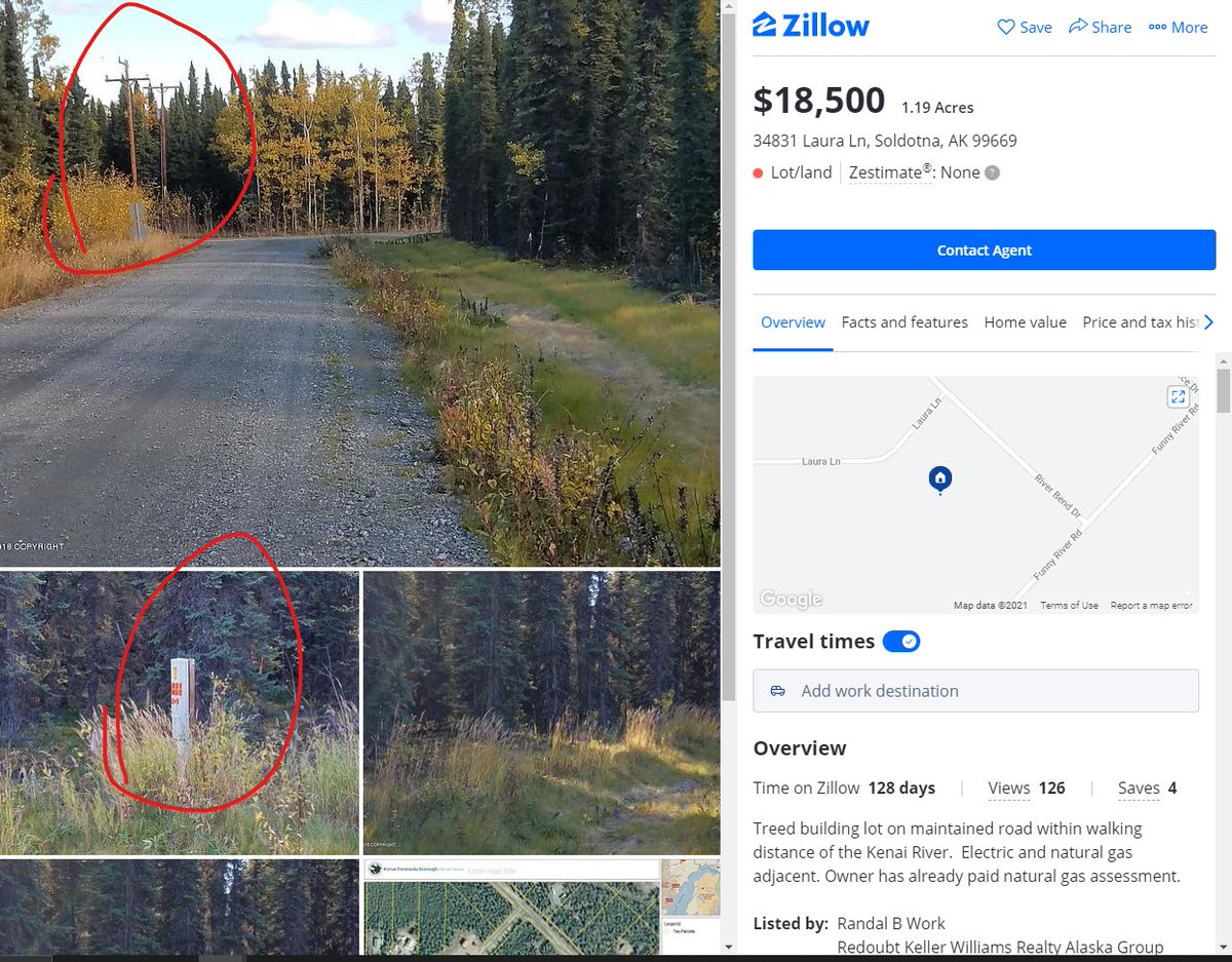
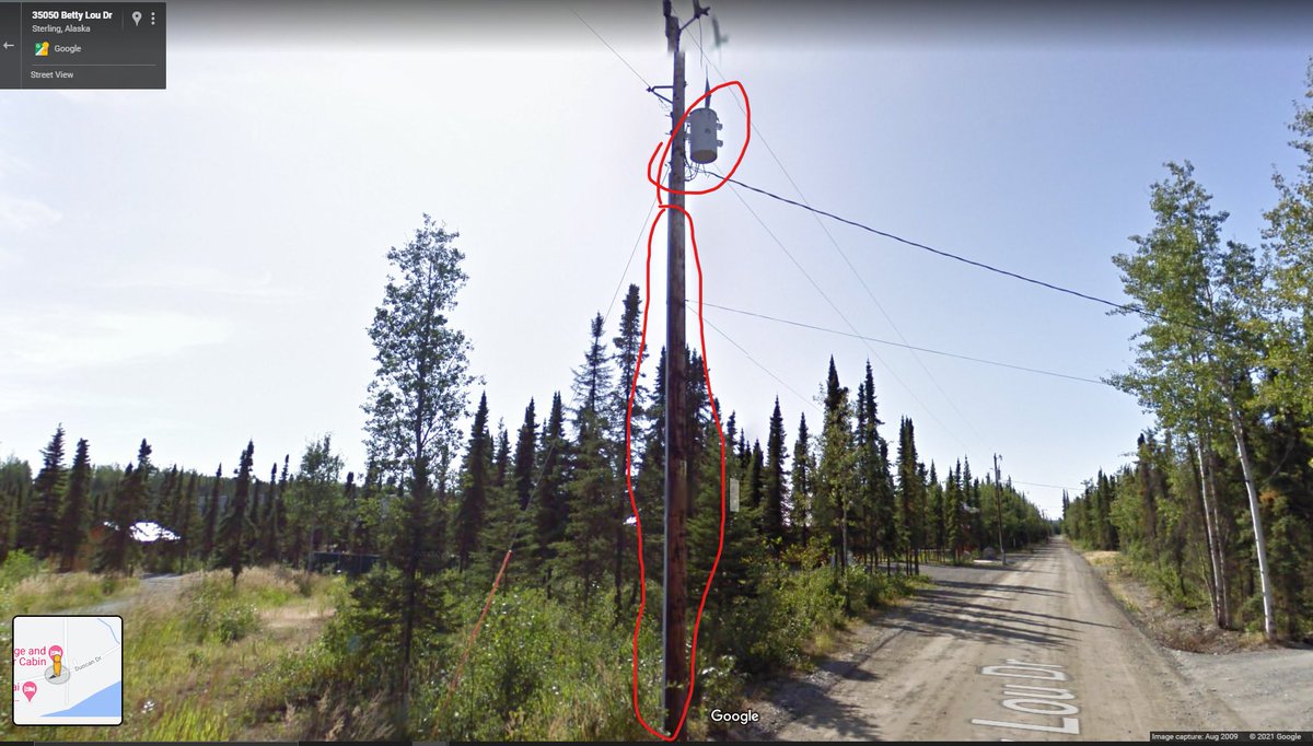
Everyone knows what a transformer looks like, even if you don't know you know. This is where a transmission or distribution line jumps down in voltage to "consumer" voltage. This is a good sign.
Note the conduit casing down the length of pole.
Now for fiber, for my work-from-home homesteaders - I had to pan over a bit to find this, but this is a good indicator that *someone* is pushing wired internet in the area.
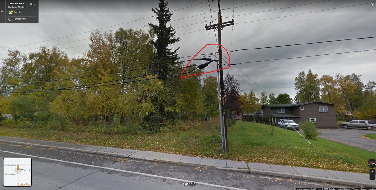
Many ISPs will have coverage maps as well.
I designed these networks for years. If a tower is nearby, you can prob get internet.
Hey there's our parcel ID number! We can use this to look up tax info at the county/borough level. Kenai's site is down right now but just imagine all the owner info appearing here.
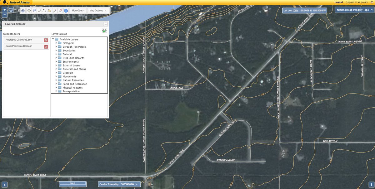
If you prefer, you can do this yourself in QGIS.
Saves us a lot of travel time and getting our hopes up.
Look at all we can grow in central Kenai!
It's important to avoid wetlands because in many parts of the country they can be considered protected habitats for waterfowl. They're also a PAIN to remediate.
Wetlands are obvious indicator septic will not work -
But a lot of properties are not so fortunate. Many I looked at in Oregon last year had well depths of over 900'. Not a typo - 900+ feet.
You should also check for deeded - in writing - access.
These can usually be determined via the plat of survey, which you should dig up for every property you look at.
More from Education

I held back from commenting overnight to chew it over, but I am still saddened by comments during a presentation I attended yesterday by Prof @trishgreenhalgh & @CIHR_IMHA.
The topic was “LongCovid, Myalgic Encephalomyelitis & More”.
I quote from memory.
1/n
#MECFS #LongCovid
The bulk of Prof @Trishgreenhalgh’s presentation was on the importance of recognising LongCovid patient’s symptoms, and pathways for patients which recognised their condition as real. So far so good.
She was asked about “Post Exertional Malaise”... 2/n
PEM has been reported by many patients, and is the hallmark symptom of ME/CFS, leading many to query whether LongCovid and ME/CFS are similar or have overlapping mechanisms.
@Trishgreenhalgh acknowledged the new @NiceComms advice for LongCovid was planned to complement... 3/n
the ME/CFS guidelines, acknowledging some similarities.
Then it all went wrong.
@TrishGreenhalgh noted the changes to the @NiceComms guidance for ME/CFS, removing support for Graded Exercise Therapy / Cognitive Behavioural Therapy. She noted there is a big debate about this. 4/n
That is correct: The BMJ published Prof Lynne Turner Stokes’ column criticising the change (Prof Turner-Stokes is a key proponent of GET/CBT, and I suspect is known to Prof @TrishGreenhalgh).
https://t.co/0enH8TFPoe
However Prof Greenhalgh then went off-piste.
5/n
The topic was “LongCovid, Myalgic Encephalomyelitis & More”.
I quote from memory.
1/n
#MECFS #LongCovid
Have you registered for IMHA's next webinar on Long-COVID? Guest speaker Professor Trisha Greenhalgh.
— CIHR-IMHA Community (@CIHR_IMHA) January 12, 2021
When? Tomorrow: *Jan 13th.* 12pm ET
A few spots are left, but going fast!
Registration required: https://t.co/T4PbWNA35Y@KarimKhan_IMHA @CIHR_IRSC @trishgreenhalgh pic.twitter.com/xlWKi4QKF1
The bulk of Prof @Trishgreenhalgh’s presentation was on the importance of recognising LongCovid patient’s symptoms, and pathways for patients which recognised their condition as real. So far so good.
She was asked about “Post Exertional Malaise”... 2/n
PEM has been reported by many patients, and is the hallmark symptom of ME/CFS, leading many to query whether LongCovid and ME/CFS are similar or have overlapping mechanisms.
@Trishgreenhalgh acknowledged the new @NiceComms advice for LongCovid was planned to complement... 3/n
the ME/CFS guidelines, acknowledging some similarities.
Then it all went wrong.
@TrishGreenhalgh noted the changes to the @NiceComms guidance for ME/CFS, removing support for Graded Exercise Therapy / Cognitive Behavioural Therapy. She noted there is a big debate about this. 4/n
That is correct: The BMJ published Prof Lynne Turner Stokes’ column criticising the change (Prof Turner-Stokes is a key proponent of GET/CBT, and I suspect is known to Prof @TrishGreenhalgh).
https://t.co/0enH8TFPoe
However Prof Greenhalgh then went off-piste.
5/n


You May Also Like


A list of cool websites you might now know about
A thread 🧵
1) Learn Anything - Search tools for knowledge discovery that helps you understand any topic through the most efficient
2) Grad Speeches - Discover the best commencement speeches.
This website is made by me
3) What does the Internet Think - Find out what the internet thinks about anything
4) https://t.co/vuhT6jVItx - Send notes that will self-destruct after being read.

Department List of UCAS-China PROFESSORs for ANSO, CSC and UCAS (fully or partial) Scholarship Acceptance
1) UCAS School of physical sciences Professor
https://t.co/9X8OheIvRw
2) UCAS School of mathematical sciences Professor
3) UCAS School of nuclear sciences and technology
https://t.co/nQH8JnewcJ
4) UCAS School of astronomy and space sciences
https://t.co/7Ikc6CuKHZ
5) UCAS School of engineering
6) Geotechnical Engineering Teaching and Research Office
https://t.co/jBCJW7UKlQ
7) Multi-scale Mechanics Teaching and Research Section
https://t.co/eqfQnX1LEQ
😎 Microgravity Science Teaching and Research
9) High temperature gas dynamics teaching and research section
https://t.co/tVIdKgTPl3
10) Department of Biomechanics and Medical Engineering
https://t.co/ubW4xhZY2R
11) Ocean Engineering Teaching and Research
12) Department of Dynamics and Advanced Manufacturing
https://t.co/42BKXEugGv
13) Refrigeration and Cryogenic Engineering Teaching and Research Office
https://t.co/pZdUXFTvw3
14) Power Machinery and Engineering Teaching and Research

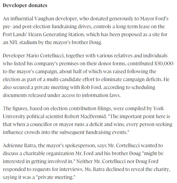
fascinated by this man, mario cortellucci, and his outsized influence on ontario and GTA politics. cortellucci, who lives in vaughan and ran as a far-right candidate for the italian senate back in 2018 - is a major ford donor...
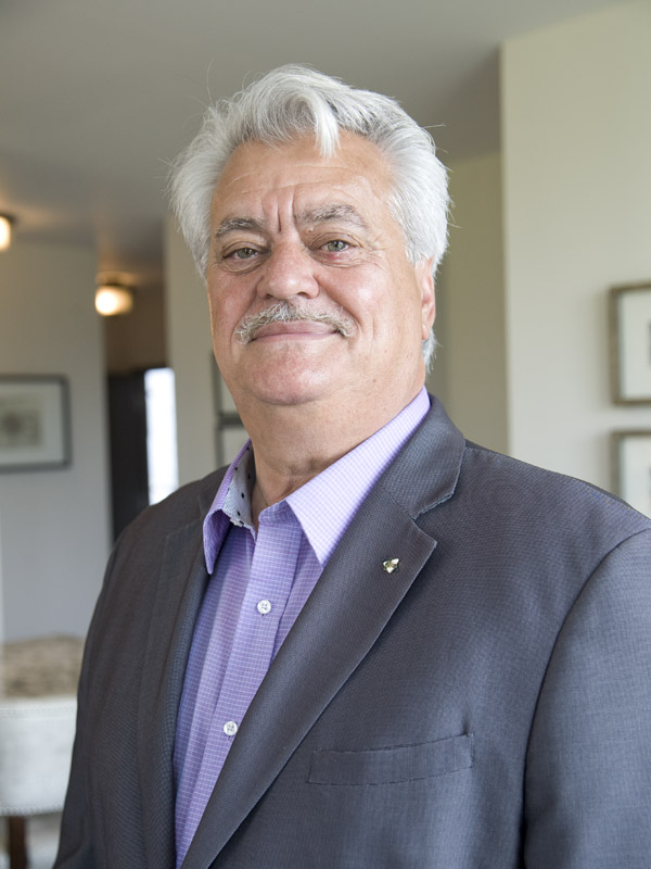
his name might sound familiar because the new cortellucci vaughan hospital at mackenzie health, the one doug ford has been touting lately as a covid-centric facility, is named after him and his family
but his name also pops up in a LOT of other ford projects. for instance - he controls the long term lease on big parts of toronto's portlands... where doug ford once proposed building an nfl stadium and monorail... https://t.co/weOMJ51bVF
cortellucci, who is a developer, also owns a large chunk of the greenbelt. doug ford's desire to develop the greenbelt has been
and late last year he rolled back the mandate of conservation authorities there, prompting the resignations of several members of the greenbelt advisory
