With that said, for my frog and frog-adjacent bros and sisters:
OK I am going to be tackling this as surveillance/open source intel gathering exercise, because that is my background. I blew away 3 years of my life doing site acquisition/reconnaissance for a certain industry that shall remain unnamed and believe there is significant carryover.
If I did thred on finding/acquiring decent raw land would that be something pepo are interested in
— Ovcharka (@ouroboros_outis) January 18, 2021
I think I know a bunch of weird tips/tricks for selection at this point that it might help u guys, lemme know
With that said, for my frog and frog-adjacent bros and sisters:
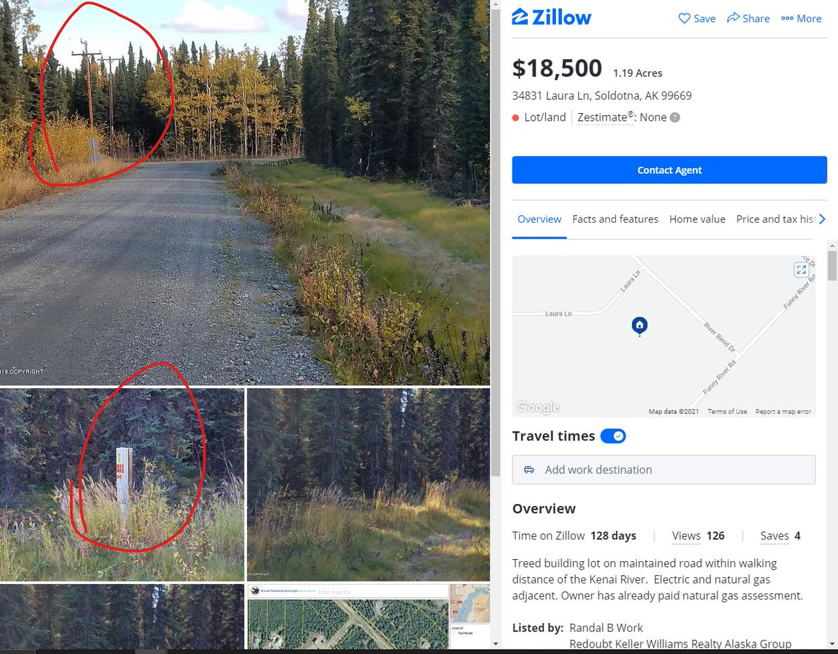
Zillow is obvious one, but there are many good sites like Billy Land, Classic Country Land, Landwatch, etc. and many of these specialize in owner financing (more on that later.) Do NOT treat these as authoritative sources - trust plat maps and parcel viewers.
Okay, everyone knows how to google "raw land in x state" but there are other resources out there, including state Departments of Natural Resources, foreclosure auctions, etc. Finding the land you like is the easy part. Let's do a case study.
Note: visible power, power/fiber pedestal, utility corridor, nearby commercial enterprise(s), and utility pole shadows visible.
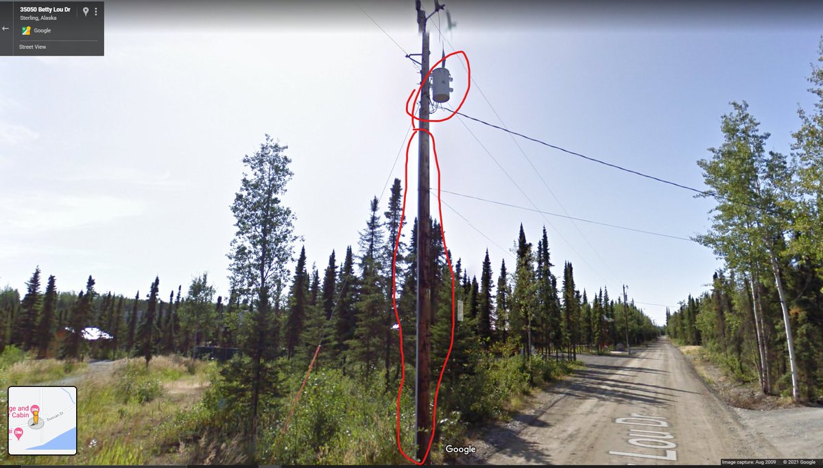
Everyone knows what a transformer looks like, even if you don't know you know. This is where a transmission or distribution line jumps down in voltage to "consumer" voltage. This is a good sign.
Note the conduit casing down the length of pole.
Now for fiber, for my work-from-home homesteaders - I had to pan over a bit to find this, but this is a good indicator that *someone* is pushing wired internet in the area.
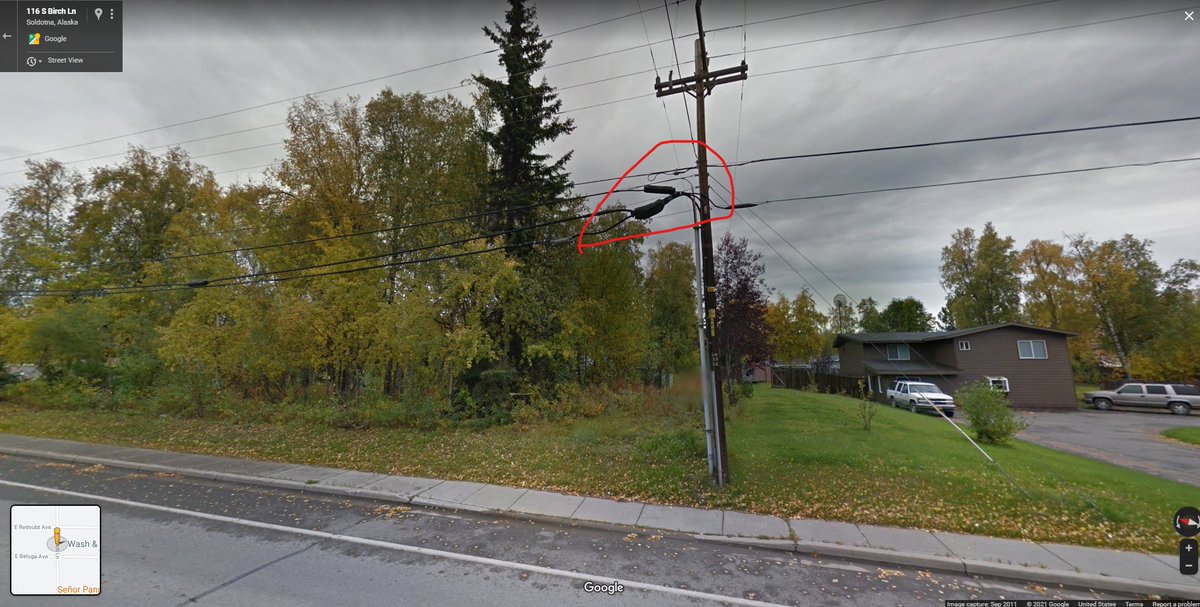
Many ISPs will have coverage maps as well.
I designed these networks for years. If a tower is nearby, you can prob get internet.
Hey there's our parcel ID number! We can use this to look up tax info at the county/borough level. Kenai's site is down right now but just imagine all the owner info appearing here.
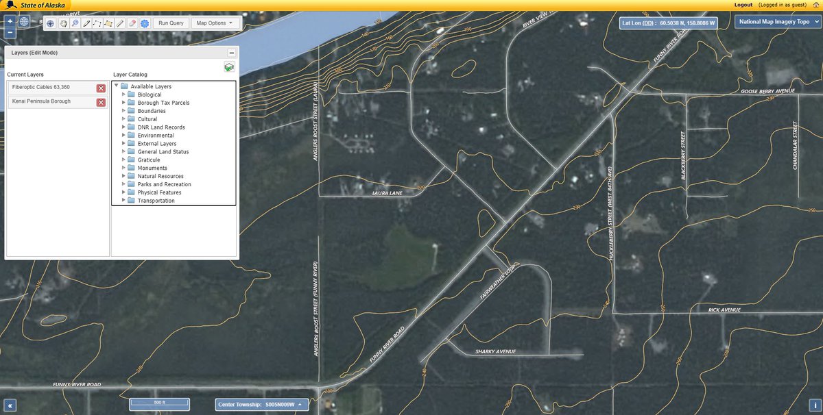
If you prefer, you can do this yourself in QGIS.
Saves us a lot of travel time and getting our hopes up.
Look at all we can grow in central Kenai!
It's important to avoid wetlands because in many parts of the country they can be considered protected habitats for waterfowl. They're also a PAIN to remediate.
Wetlands are obvious indicator septic will not work -
But a lot of properties are not so fortunate. Many I looked at in Oregon last year had well depths of over 900'. Not a typo - 900+ feet.
You should also check for deeded - in writing - access.
These can usually be determined via the plat of survey, which you should dig up for every property you look at.
More from Education

Last month I presented seven sentences in seven different languages, all written in a form of the Chinese-character script. The challenge was to identify the languages and, if possible, provide a
Here again are those seven sentences:
1) 他的剑从船上掉到河里去
2) 於世𡗉番𧡊哭唭𢆥尼歲㐌外四𨑮
3) 入良沙寢矣見昆腳烏伊四是良羅
4) 佢而家喺邊喥呀
5) 夜久毛多都伊豆毛夜幣賀岐都麻碁微爾夜幣賀岐都久流曾能夜幣賀岐袁
6) 其劍自舟中墜於水
7) 今天愛晚特語兔吃二魚佛午飯
Six of those seven sentences are historically attested. One is not: I invented #7. I’m going to dive into an exploration of that seventh sentence in today’s thread.
Sentence #7 is an English-language sentence written sinographically — that is, using graphs that originate in the Chinese script. I didn’t do this for fun (even though it is fun), or as a proposal for a new way to write
I did it as a thought experiment. Why? Because thinking about how the modern Chinese script might be adapted to write modern English can give us valuable insights into historical instances of script borrowing, like those that took place centuries ago in Japan, Korea, and Vietnam.
\U0001f17b\U0001f130\U0001f17d\U0001f176\U0001f184\U0001f130\U0001f176\U0001f174 \U0001f180\U0001f184\U0001f178\U0001f189
— zev handel (@ZevHandel) December 17, 2020
The following sentences are in seven different languages, all written in Chinese-character script (or a modification of it). Can you identify the languages?
Sentences are in thread.
(1/3)
Here again are those seven sentences:
1) 他的剑从船上掉到河里去
2) 於世𡗉番𧡊哭唭𢆥尼歲㐌外四𨑮
3) 入良沙寢矣見昆腳烏伊四是良羅
4) 佢而家喺邊喥呀
5) 夜久毛多都伊豆毛夜幣賀岐都麻碁微爾夜幣賀岐都久流曾能夜幣賀岐袁
6) 其劍自舟中墜於水
7) 今天愛晚特語兔吃二魚佛午飯
Six of those seven sentences are historically attested. One is not: I invented #7. I’m going to dive into an exploration of that seventh sentence in today’s thread.
Sentence #7 is an English-language sentence written sinographically — that is, using graphs that originate in the Chinese script. I didn’t do this for fun (even though it is fun), or as a proposal for a new way to write
7) \u4eca\u5929\u611b\u665a\u7279\u8a9e\u5154\u5403\u4e8c\u9b5a\u4f5b\u5348\u98ef \u2013 Modern English
— zev handel (@ZevHandel) December 21, 2020
Today I want you to each two fish for lunch.
That this sentence is a written form of English is undeniable, as the sentence is made up entirely of English words following the rules of English grammar. 23/
I did it as a thought experiment. Why? Because thinking about how the modern Chinese script might be adapted to write modern English can give us valuable insights into historical instances of script borrowing, like those that took place centuries ago in Japan, Korea, and Vietnam.


This is the steady stream of propaganda that's going to be hitting us daily, selling "deprogramming" and "re-education" as normal and reasonable, attempting to convince us that the Biden-Harris side is the good-guy side, admittedly 'backed by corporate billionaires'.
Don\u2019t know who this dude is but he broke that shit DOWN!! Listen especially the ones that need to hear it!! pic.twitter.com/gSZno2yaRh
— Leslie Jones \U0001f98b (@Lesdoggg) January 17, 2021

You May Also Like


Ivor Cummins has been wrong (or lying) almost entirely throughout this pandemic and got paid handsomly for it.
He has been wrong (or lying) so often that it will be nearly impossible for me to track every grift, lie, deceit, manipulation he has pulled. I will use...

... other sources who have been trying to shine on light on this grifter (as I have tried to do, time and again:
Example #1: "Still not seeing Sweden signal versus Denmark really"... There it was (Images attached).
19 to 80 is an over 300% difference.
Tweet: https://t.co/36FnYnsRT9

Example #2 - "Yes, I'm comparing the Noridcs / No, you cannot compare the Nordics."
I wonder why...
Tweets: https://t.co/XLfoX4rpck / https://t.co/vjE1ctLU5x

Example #3 - "I'm only looking at what makes the data fit in my favour" a.k.a moving the goalposts.
Tweets: https://t.co/vcDpTu3qyj / https://t.co/CA3N6hC2Lq

He has been wrong (or lying) so often that it will be nearly impossible for me to track every grift, lie, deceit, manipulation he has pulled. I will use...
... other sources who have been trying to shine on light on this grifter (as I have tried to do, time and again:
Ivor Cummins BE (Chem) is a former R&D Manager at HP (sourcre: https://t.co/Wbf5scf7gn), turned Content Creator/Podcast Host/YouTube personality. (Call it what you will.)
— Steve (@braidedmanga) November 17, 2020
Example #1: "Still not seeing Sweden signal versus Denmark really"... There it was (Images attached).
19 to 80 is an over 300% difference.
Tweet: https://t.co/36FnYnsRT9
Example #2 - "Yes, I'm comparing the Noridcs / No, you cannot compare the Nordics."
I wonder why...
Tweets: https://t.co/XLfoX4rpck / https://t.co/vjE1ctLU5x
Example #3 - "I'm only looking at what makes the data fit in my favour" a.k.a moving the goalposts.
Tweets: https://t.co/vcDpTu3qyj / https://t.co/CA3N6hC2Lq